Day 06Start - Gargrave - OS Grid Ref:- SD 93296 54260 - Height:- 110.00m
Day 06Route - Gargrave->Malham
Days Walk:- 6.98 Miles
Days Ascent:- 284.28m
Start Time:- 13:30, Finish Time:- 17:45
Walking Time:- 4hrs 15mins
Average Speed:- 1.64mph
Places of Interest:-
Ayre Head
Peaks visited:-
None
PHOTOS (DAY 06)
DAYS JOURNAL (DAY 06)
 |
| Opening lock gates on Leeds & Liverpool Canal just before Chew Lane |
 |
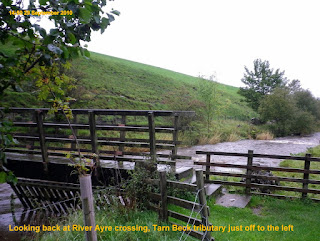
| Looking back at River Ayre crossing, Tarn Beck tributary just off to the left |
I was ready to leave fully refreshed and clean by about 12:30, a little later than I had planned but still expect to reach Malham by 15:30. Walking through Malham I call into a butchers and bought some mince meat. On the other side of the road there is a co-op, so I buy the ingredients to make myself a chilli as well as fresh milk.
 |
| Newfield Bridge |
Reaching the road I followed it to Airton where at the Tarn Dike bridge I realised I should have stayed on the other side of the wall and on the path and field about 10ft below. Fortunately (for me, not the car) a car had hit the wall and I was able to lower myself down through this gap in the wall.
 |
| Looking back at Airton bridge crossing |
From here Malham Cove is viewed for the first time and in front of it is Malham the days end point.
Compared to previous days not only was this the shortest walk but also the easiest. In essence a stroll along the Aire Valley. The last part of the walkwas the hardest, to Hill Top Farm bunkhouse was believe it or not at the top of a hill. So I was well ready for a warm room and a welcoming cup of tea provided by 3 hostellers who I would be sharing with me that night.
 |
| Malham Cove from AyreHead |
Oh well 2 out of 3 was not bad. The shower was brilliant I was being spoilt having a wash 2 days on the trot whether I needed it or not. Also the chilli was brilliant even though I do say so myself. Again a double portion with pasta.
This walking lark is brilliant all you have to worry about is getting enough to eat and finding somewhere dry to sleep. If it is also warm that is a bonus and if it has a shower a double bonus. After eating I was too tired to bother walking to the pub so again an early night ready for an early start to what will be a long hard day tomorrow.
It turns out the 3 hostellers are moving on tomorrow as well to Horton, which happens to be my destination. They kindly offer to take my back pack for me but for some reason I have become attached to it In my mind I would be cheating. I want to say I walked the Pennine Way, all of it, with 60lbs on my back.
"Where is it written down that you have to do that" I am asked.
"No where" I reply"
"Except in my head"
I must be mad
MAP DAY 06
ROUTE CARD DAY 06
| LOCATION | HEIGHT | DIST | ASCT | |
| The Old Swan Inn, Gargrave | SD 93296 54260 | 110.00 m | ||
| The Old Swan Inn, Gargrave->The Dalesman Cafe, Gargrave | 0.11 Mi | .2 m | ||
| The Dalesman Cafe, Gargrave | SD 93183 54128 | 108.10 m | ||
| The Dalesman Cafe, Gargrave->Chew Lane, Gargrave | 0.25 Mi | 6.5 m | ||
| Chew Lane, Gargrave | SD 93076 54480 | 112.00 m | ||
| Chew Lane, Gargrave->FP to Middle Plantation | 0.54 Mi | 39.2 m | ||
| FP to Middle Plantation | SD 92461 55006 | 143.99 m | ||
| FP to Middle Plantation->SW corner of Steeple Plantation | 0.93 Mi | 65.4 m | ||
| SW corner of Steeple Plantation | SD 91885 56126 | 199.72 m | ||
| SW corner of Steeple Plantation->Haw Crag (to left) | 0.29 Mi | 6.3 m | ||
| Haw Crag (to left) | SD 91671 56508 | 200.55 m | ||
| Haw Crag (to left)->Newfield Bridge | 1.27 Mi | 12 m | ||
| Newfield Bridge | SD 90732 58106 | 146.49 m | ||
| Newfield Bridge->Airton | 0.79 Mi | 23.6 m | ||
| Airton | SD 90422 59212 | 162.04 m | ||
| Airton->Crook Syke | 0.39 Mi | 14.4 m | ||
| Crook Syke | SD 90199 59754 | 162.07 m | ||
| Crook Syke->Hanlith Hall | 1.01 Mi | 47 m | ||
| Hanlith Hall | SD 90071 61237 | 193.84 m | ||
| Hanlith Hall->Aire Head | 0.69 Mi | 37.5 m | ||
| Aire Head | SD 90271 62171 | 186.85 m | ||
| Aire Head ->FP to Hill Top Farm | 0.65 Mi | 20.6 m | ||
| FP to Hill Top Farm | SD 89986 63120 | 203.85 m | ||
| FP to Hill Top Farm->Hill Top Farm, Malham | 0.07 Mi | 8.9 m | ||
| Hill Top Farm, Malham | SD 89934 63055 | 211.32 m | ||
| Total trip | 6.99 Mi | 281.5 m |

No comments:
Post a Comment